Eastern Pacific hurricane season refuses to die
 Print This Print This
By Richard Angwin, Al Jazeera
Al Jazeera
Tuesday, Nov 24, 2015
2015 will go down as the longest-lasting hurricane season, and one of the most active on record.
A tropical depression, lying some 500km to the southwest of Mexico's holiday resort of Acapulco, is expected to intensify in the coming days.
It is likely to affect both local people and the many thousands of holidaymakers enjoying a Thanksgiving holiday break.
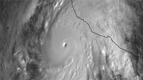 |
| Patricia was the strongest cyclone ever recorded in the Western Hemisphere [EPA/NASA] |
The low pressure system, currently known as 22E, is expected to intensify into Tropical Storm Sandra before reaching hurricane strength by Thursday.
The Eastern Pacific hurricane season formally runs from May 15 to November 30. The 2015 season has been exceptional in several respects.
The season started early, and looks like finishing late. It began with a major - Category 4 on the five-point Saffir-Simpson scale - hurricane, Andres, on May 29.
Hurricanes Blanca and Carlos followed during early June; Dolores and Guillermo followed in July; Hilda, Kilo, Ignacio and Jimena in August; and Linda, Marty and Oho in September.
There was a hiatus during the first half of October, but any complacency was dispelled with the formation of Olaf. Like most of its predecessors, it remained offshore.
If the season had ended there, it would still have been one of the most active on record. But then along came Patricia …
Patricia formed on October 22, before undergoing explosive intensification. Within a matter of hours, Patricia was a Category 5 storm.
Unlike many of its predecessors, Patricia took a turn towards shore. There was concern about potential loss of life, especially after sustained winds of 325kph were recorded, along with a central pressure of 879 millibars.
Patricia was the strongest cyclone ever recorded in the western hemisphere. Fortunately, as it made landfall, it passed between major towns, hitting a relatively unpopulated region. Mexicans breathed a collective sigh of relief.
Now, as we approach the end of the official season, Sandra threatens to become the 16th hurricane of the year. It is not expected to become a major system - Category 3 or above - but it will have contributed to the season with the highest number of depressions (30), and major hurricanes (10), tying with 1992.
Should Sandra come inland, it will be the latest storm to make landfall in the Eastern Pacific ever recorded.
The driving force behind this active season is the ongoing El Nino. Average sea surface temperatures across the central Pacific region are 3.1C above average, exceeding the previous record of 2.8C during the same week in 1997, the last major El Nino.
With such extreme sea surface temperatures, it is certainly possible that there could be more storms up until the end of the year.
Source URL
|
 Print This Print This

|
