Where is the "garbage patch"?
The concentrations of marine debris ("garbage patches") that have been covered in the media are within the North Pacific Subtropical Convergence Zone (STCZ) (see map, Convergence Zone) – sometimes referred to as the “trash superhighway” that connects the "eastern and western garbage patches". It is our belief that these “patches” lie within the STCZ.
The North Pacific Subtropical Convergence Zone (STCZ) is a known area of marine debris accumulation in the North Pacific Ocean. This area does not have distinct boundaries and varies in strength and location throughout the year. This amorphous area moves seasonally between 23° and 37° N latitude. The STCZ shifts farther southward during periods of El Niño.
[Note: There are approximately 70 miles between degrees of latitude; 23° and 37° N latitude would span a distance of approximately 1000 miles.]
What is the difference between the "gyre" and the "garbage patch"? Or are they the same thing?
A gyre is any manner of swirling vortex often used to describe large-scale ocean currents. Worldwide, there are five major large-scale subtropical oceanic gyres that are formed by ocean currents. They are the North and South Pacific Subtropical Gyres, the North and South Atlantic Subtropical Gyres, and the Indian Ocean Subtropical Gyre. The North Pacific Subtropical Gyre is the gyre most notably known for collecting debris and is made up of four large, clockwise-rotating currents – North Pacific, California, North Equatorial, and Kuroshio (see map).
It is not the gyre itself or “garbage patch” that concentrates the debris but the North Pacific Subtropical Convergence Zone (STCZ) (see map). This convergence zone is sometimes referred to as the “trash superhighway” that connects the “Eastern and Western Garbage Patches.” It is our belief that these “patches” lie within the STCZ. The STCZ moves seasonally between 23° and 37° N latitude which spans a distance of approximately 1000 miles. The STCZ shifts farther southward during periods of El Niño.
Can you see the "garbage patch" with satellite photos?
Fishermen and others who have sailed the area have reported "patches" of concentrated floating debris. Relative to the expanse of the North Pacific Ocean, sightings of large debris items or large concentrations of debris are not very common. Most of the reports we have received and studies that have been conducted report that the observation of large items that are visible from a ship’s deck are few and far between. A majority of the debris observed in the STCZ is small plastic pieces. Small debris pieces are difficult to see due to their size, and a majority of these pieces are suspended at or just below the surface of the water, thus making it difficult to observe. For these reasons, the debris, or “patch” of debris is not visible using satellite photos.
How big is the “garbage patch”?
There's really no accurate estimate out there on the size of this debris hot spot. The STCZ, which contains the debris, does not have distinct boundaries and thus the debris in this area cannot be accurately measured. The STCZ is an enormous area without an even distribution of marine debris--it might be a net here, or a buoy there, then in other areas a good-sized swath of litter items, or sub-surface pieces.
What is being done to clean up the plastics and debris in the “garbage patch”?
NOAA has been researching the North Pacific Subtropical Convergence Zone (STCZ) (the N. Pacific area where marine debris concentrates) for several years, mainly because the convergence is the primary mechanism that leads to marine debris accumulation (and thus impacts) in the Hawaiian Archipelago. We've been contacted by several companies with ideas for cleanup of the debris in the so-called "garbage patch." However, clean up is more difficult than it may seem.
This area, the STCZ, shifts seasonally between 23 deg. and 37 deg. N. latitude; its location is also affected by other factors including El Niño. Not only does marine debris concentrate in this area, but marine life does as well. This makes simple scooping up of the material risky—you may cause more harm than good. Remember that much of our ocean life is in the microscopic size range. Also, because this area moves within the N. Pacific Ocean (a very large area in and of itself), you can imagine the difficulty in finding the concentrated marine debris on a given day.
NOAA has developed experimental maps that can help predict the location of this STCZ; however, even these maps are not perfect. Also, because the concentrated debris is still difficult to see, even if you are in the area of the STCZ (much of the debris is tiny, dispersed, or below the surface), removal methods are still, with current resources, not cost-effective and may not be successful.
Can you confirm that the “garbage patch” exists?
NOAA has been researching marine debris concentration and movement within the STCZ for several years. Marine debris concentrations there definitely exist!
Is there a "garbage patch" in the Atlantic Ocean?
Much of the research on oceanic movement and concentration of marine debris has focused on the Pacific Ocean possibly because these mechanisms lead to the accumulation, and thus impacts, of marine debris across the Hawaiian Archipelago. In particular, research has been done on the North Pacific Subtropical Convergence Zone, a known area of debris accumulation in the N. Pacific. Additionally, perhaps due to the numerous protected species and resources within the Hawaiian Archipelago (e.g., endangered Hawaiian monk seal), research on threats, such as marine debris, tend to rise in priority.
This is not to say that marine debris in the Atlantic Ocean is not important. There has been research conducted and published on marine debris in the Atlantic, mainly on ingestion in Atlantic species of sea turtles and seabirds or nearshore trawls for plastic particles. Still, there is a paucity of literature on marine debris in the high-seas Atlantic Ocean. Much like in the Pacific there is a North Atlantic Gyre made up of four major currents – North Equatorial, Gulf Stream, North Atlantic, and Canary Current. There is also a North Atlantic Subtropical Convergence Zone (STCZ); however, we currently know of no research on debris concentration within this STCZ.
NOAA

 Print This
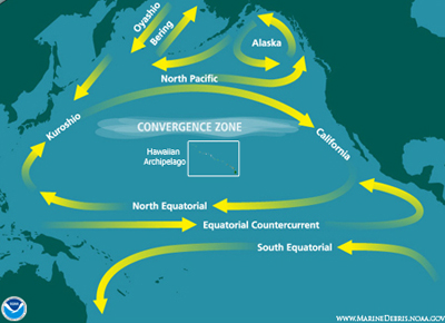
 Print This